美国地理(中文英文都要有哦)
 7cyx_zd2022-10-04 11:39:541条回答
已提交,审核后显示!提交回复
共1条回复
 任我oo行 共回答了14个问题
 |采纳率100%- 1.纽约 NewYork 2.洛杉矶 LosAngeles 简写:L.A.
3.华盛顿 Washington D.C. - 1年前
相关推荐
- 读美国图,做4~5题.关于美国地理信息的描述不正确的是( )A.区域专门化是美国农业生产的一大特点B.东北部气候冷湿,
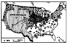 读美国图,做4~5题.
关于美国地理信息的描述不正确的是( )
A.区域专门化是美国农业生产的一大特点
B.东北部气候冷湿,适宜牧草生长,发展成乳畜带
C.五大湖是美国最重要的灌溉水源
D.南部棉花带形成的有利条件是热量充足,土壤肥沃,灌溉便利mmyly1年前1 -
nilk_duan 共回答了18个问题
|采纳率94.4%解题思路:美国主要的灌溉水源是密西西比河,该河流是世界第四长河,发源于大平原,自北向南注入墨西哥湾.美国主要的灌溉水源是密西西比河,不是五大湖,选项ABD叙述正确,不符合题意.
故选:C.点评:
本题考点: 北美的密西西比河和五大湖.
考点点评: 本题考查美国的农业、河流等,熟记课本知识点解答即可.1年前查看全部
- 读美国图,做13~14题.关于图中美国地理信息的描述不正确的是( )A.区域专门化是美国农业生产的一大特点B.东北部气
 读美国图,做13~14题.
关于图中美国地理信息的描述不正确的是( )
A.区域专门化是美国农业生产的一大特点
B.东北部气候冷湿,适宜牧草生长,发展成乳畜带
C.五大湖是美国最重要的灌溉水源
D.南部棉花带形成的有利条件是热量充足,土壤肥沃,灌溉便利阿尔它夏的他1年前1 -
canghai2008 共回答了12个问题
|采纳率100%解题思路:美国是世界上的农业大国,是世界上主要的农产品生产国和出口国,并且实现了农业生产专门化,机械化水平高,效率高,产量大.美国的灌溉水源是密西西比河,选项C叙述错误,选项ABD叙述正确,不符合题意.
故选:C.点评:
本题考点: 北美的密西西比河和五大湖.
考点点评: 本题考查美国的农业和灌溉性河流,牢记即可.1年前查看全部
- 读美国图,做问题。 小题1:关于美国地理信息的描述不正确的是 A.区域专门化是美国农业生产的一大特点 B.东北部气候冷湿
读美国图,做问题。

小题1:关于美国地理信息的描述不正确的是
土壤肥沃,灌溉便利A.区域专门化是美国农业生产的一大特点 B.东北部气候冷湿,适宜牧草生长,发展成乳畜带 C.五大湖是美国最重要的灌溉水源 D.南部棉花带形成的有利条件是热量充足,
小题2:美国经济增长中至少有27%归功于高新技术产业,著名的高新技术产业中心“硅谷”所在城市是A.① B.② C.③ D.④ 书楠1年前1 -
无花蔷薇0 共回答了24个问题
|采纳率100%小题1:C
小题2:D
小题1:本题主要考查的是美国的相关知识。美国的农业生产特点是实现了区域专业化;美国东北部地区纬度高,气候冷湿,适宜牧草生长,发展成乳畜带;美国农业主要位于中部平原地区,密西西比河及其支流是美国最重要的灌溉水源;南部棉花带形成的有利条件是热量充足,土壤肥沃,灌溉便利。
小题2:本题主要考查的是美国的相关知识。美国的“硅谷”所在的城市为旧金山,图中④城市。1年前查看全部
- 关于美国地理位置的描述,正确的是( ) A.大部分在热带 B.大部分在南温带 C.大部分在北寒带 D.大部分在北温带
广州小坏孩儿1年前1
-
秋天来了还不行吗 共回答了22个问题
|采纳率90.9%美国的领土由本土和两个海外州组成,本土位于北温带;阿拉斯加州被北极圈穿过,跨北寒带和北温带;夏威夷州位于热带海洋之中.故美国领土大部分位于北温带.
故选:D.1年前查看全部
- 用英语介绍美国地理急需关于美国地理的英语介绍文章.最好有中文,比较长或比较难的单词最好有音标.
SoloMant1年前4
-
waiyuaihaozhe 共回答了24个问题
|采纳率91.7%The United States is located in southern North America, east to the Atlantic,
West Pacific, north of Canada, South to Mexico and the Gulf of Mexico. The whole
territory from east to west can be divided into 5 geographical regions: the
coastal plain in southeastern coastal plain is divided into two parts of the
Atlantic and Mexico coastal plain. This is an area of at an elevation of 200
meters below, the majority formed by the alluvial rivers, especially the
Mississippi River Delta, Delta, the world's largest soil and oil, fertile soil.
There are some swamps near the mouth of the river. Located in the geographical
area of the Florida Peninsula is the United States of America's largest
peninsula.
The Appalachian Mountains located in the west of the Atlantic
coastal plain, basic parallel with the coast, more than 2300 km long, the
general elevation of 1000 ~ 1500 meters, composed of several parallel mountains.
The plain was inverted triangle, long North American and Canadian border, south
the Atlantic Coastal Plains along the Rio Grande river. Western mountains from
the west is composed of two mountains, east of Rocky Mountains, west of the
Sierra Nevada mountains and the cascade mountains. A product of the old fold
after exercise. Whitney Nevada mountain peak 4418 meters above sea level, as the
United States, the highest point, the Cascade Mountains of Mount Rainier 4392
meters, after Whitney peak. Western mountain plateau by the Colorado plateau,
Wyoming plateau, Columbia Plateau and the Grand Canyon, the most complex
geological structure in the western region of the United States of america. The
Grand Canyon is located in the northwest part of Arizona, a series with many
twists and turns, perplexing and deep valley gorge, the momentum of the
majestic, steep rock wall, as the world's rare natural landscape. The United
States has numerous rivers and lakes, water complex, in general can be divided
into three major river systems: where is located in the east of the rocky
mountains into the the Atlantic River are called the Atlantic river system,
mainly in the Mississippi River, Connecticut River and the Hudson river. The
Mississippi River is full-length 6020 kilometers, ranking third in the world.
Where a river called into the Pacific Ocean water. Mainly in the Colorado River,
Columbia River, Yukon etc.. North America east of the Great Lakes group.
Including Lake Superior, Lake Michigan, Lake Huron, Lake Erie and lake Ontario,
a total area of 245000 square kilometers, is the world's largest freshwater,
known as the "North American Mediterranean", the Michigan lake is the United
States of America, the other 4 Lake as the United States and canada. Lake
Superior is the world's largest freshwater lake, the lake area in the world only
to the Caspian Sea and ranked the second in the world.
In most parts of
the United States of America's climate is temperate and subtropical climate,
only the tip of the Florida Peninsula tropical. Northern California is located
in north latitude 60 to 70 degrees, is the cold Arctic climate zone; Hawaii
Prefecture is located to the south of the Tropic of cancer, is a tropical
climate zone. But because the United States has a vast territory, complicated
terrain, different climate. Can be divided into 5 climatic zones: the northeast
coast temperate climate zone. This area because of the impact, the Labrador
Current and the cold northern winter, the average January temperature is -6 ℃,
mild and rainy in summer, in July the average temperature is about 16 ℃. Average
annual precipitation is about 1000 mm. Southeast subtropical climate zone.
Because of the influence of Mexico gulf stream, warm and humid climate, the
average January temperature is 96 ℃, the average July temperature of 24 ~ 27 ℃,
the average annual rainfall of 1500 mm. Central Plains continental climate zone.
This area is characteristic of the climate, the winter cold, in January, the
average temperature of -14 ℃, hot summer, the average temperature in July up to
27 ~ 32 ℃. Average annual precipitation is 1000 ~ 1500 mm. The western plateau
dry climate zone. The regional inland climate, large temperature difference
between the plateau last year, Colorado plateau temperature up to 25 ℃. The
average annual precipitation 500 mm below the desert plateau, less than 250 mm
of precipitation. Along the coast of the Pacific Ocean Climate zone. Winter in
the region, with plenty of rainfall. In January the average temperature over 4
℃, the average July temperature of 20 ~ 22 ℃. Average annual precipitation is
about 1500 mm.
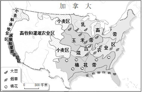
The United States agricultural, mineral and forest
resources play a decisive role, plays a role in the world. The United States of
America's geographical location, climate and terrain structure is be richly
endowed by nature. The United States agricultural land (cultivated land and
pasture) of about 430000000 hectares, accounting for all of earth agriculture
with around 10%. Abundant rainfall, fertile soil, of the world's total grain
output of 1/5, the main agricultural products such as wheat, corn, soybean,
cotton, meat production ranks first in the world.
The United States is
rich in mineral resources, iron ore, coal, natural gas, lead, zinc, silver,
molybdenum, zirconium, uranium output occupies the world front row, but
strategic resources such as titanium, manganese, tin, cobalt, chromium, nickel,
mainly rely on imports. The total coal reserves of 35996 tons, the total oil
reserves of about 24000000000 tons, natural gas reserves of 5603400000000 cubic
meters.
The United States has 1800000000 hectares of forest, accounted
for about 31.5% of the total land area, the main tree species are pine,
ponderosa pine, American white pine and oak class.
1年前查看全部
- 看图填出美国地理事物名称:(1)农业带:A______带,B______带(2)美国地形分布特点:______(3)城市
看图填出美国地理事物名称:
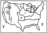
(1)农业带:A______带,B______带
(2)美国地形分布特点:______
(3)城市:美国首都是______,高新技术产业中心城市--“硅谷”:______.33968681年前1 -
pradaye 共回答了20个问题
|采纳率95%解题思路:美国是世界上经济发达国家,其地形地形分布特点是西部是高大的落基山脉,中部是广阔的大平原,东部是低缓的阿巴拉契亚山脉.(1)读图知,A是玉米带;B是小麦区;
(2)美洲西部是高大的落基山脉,中部是广阔的大平原,东部是低缓的阿巴拉契亚山脉;
(3)美国首都是华盛顿;高新技术产业中心城市--“硅谷”是旧金山.
故答案为:(1)玉米;小麦;(2)西部是高大的落基山脉,中部是广阔的大平原,东部是低缓的阿巴拉契亚山脉;(3)华盛顿;旧金山.点评:
本题考点: 美国主要农产品和农业带的分布.
考点点评: 本题考查了美国的相关知识点.1年前查看全部
- 读图,完成19-22题.关于美国地理位置的描述,正确的是( )A.位于北美洲北部B.大部分位于低纬度地区C.东临大西洋
读图,完成19-22题.
关于美国地理位置的描述,正确的是( )
A.位于北美洲北部
B.大部分位于低纬度地区
C.东临大西洋,西临太平洋
D.是北美洲面积最大的国家毕业llll1年前1 -
LYJSY2008 共回答了14个问题
|采纳率78.6%解题思路:美国本土位于北美洲中南部,东、西、南三面分别濒临大西洋、太平洋和墨西哥湾,北与加拿大接壤,西南与墨西哥毗邻.领土还包括北美洲西北部的阿拉斯加和太平洋上的夏威夷群岛.美国本土位于北美洲中南部,故A不正确;
美国本大部分位于中纬度地区,故B不正确;
美国东临大西洋,西临太平洋,故C正确;
北美洲面积最大的国家是加拿大,故D不正确.
故选:C.点评:
本题考点: 美国的地理位置和领土组成.
考点点评: 本题主要考查了美国的位置,结合地图回答即可.1年前查看全部
- 下列关于美国地理位置的叙述,正确的是( )
下列关于美国地理位置的叙述,正确的是( )
①美国东临大西洋,东南临加勒比海
②美国西临太平洋,阿拉斯加州隔白令海峡与俄罗斯相望
③美国北邻加拿大,南邻墨西哥两者都是北美洲的发达国家
④美国本土全部位于北温带.
A.①②
B.③④
C.②④
D.①③purestayly1年前1 -
hamas317 共回答了18个问题
|采纳率88.9%解题思路:习惯上人们将北美洲中部的美国国土主体部分称为美国本土,其东临大西洋,西临太平洋.另外还有两个海外州:北美洲西北部隔白令海峡与俄罗斯相望的阿拉斯加州和太平洋北部的夏威夷州.美国东临大西洋,南临墨西哥湾,西临太平洋,阿拉斯加州隔白令海峡与俄罗斯相望;美国北邻加拿大,南邻墨西哥,加拿大是北美洲的发达国家,墨西哥是北美洲的发展中国家;美国本土全部位于北温带.故选项C符合题意.
故选:C.点评:
本题考点: 美国的地理位置和领土组成.
考点点评: 本题考查美国的地理位置.1年前查看全部
- 懂美国地理知识的进来,关于州Use the words in parentheses () to change each
懂美国地理知识的进来,关于州
Use the words in parentheses () to change each sentence into a negative statement.
Alaska is a big state(Maryland and Delaware)
_________________________________________1214489601年前2 -
余香肉丝 共回答了29个问题
|采纳率93.1%Maryland and Delaware are not big states.1年前查看全部
- 有关美国地理的英语文章300字左右,
lklkk1年前1
-
cainiao007008 共回答了13个问题
|采纳率100%The United States is the world's third or fourth largest nation by total area,before or after the People's Republic of China,depending on how two territories disputed by China and India are counted.In...1年前查看全部
- 读美国图,做13~14题.13.关于图中美国地理信息的描述不正确的是( )14.美国经济增长中至少有27%归功于高新技
 读美国图,做13~14题.
13.关于图中美国地理信息的描述不正确的是( )
14.美国经济增长中至少有27%归功于高新技术产业,著名的高新技术产业中心“硅谷”所在城市是( )
A.①
B.②
C.③
D.④luoxiaoweiyu1年前1 -
WNDD 共回答了16个问题
|采纳率100%解题思路:美国人口3.07亿(2009年),居世界第3位.
美国首都华盛顿位于哥伦比亚特区.这里有很多纪念性建筑,其中华盛顿纪念碑、杰弗逊纪念堂、林肯纪念堂最为著名.
纽约是美国人口最多的城市、最大的港口,也是世界四大金融中心之一.曼哈顿区被视为纽约市的象征.华尔街一带摩天大楼林立,金融、保险机构众多.
洛杉矶是美国太平洋沿岸的最大港口城市和经济、文化中心,享誉世界的“电影城”好莱坞和世界第一个迪斯尼乐园都在这里.
圣弗朗西斯科又称旧金山,是美国太平洋沿岸重要的金融、贸易和文化中心,也是著名的天然良港.以斯坦福大学等高校和科研院所为依托的“硅谷”,是全球闻名的高新技术产业区.圣弗朗西斯科又称旧金山,是美国太平洋沿岸重要的金融、贸易和文化中心,也是著名的天然良港.以斯坦福大学等高校和科研院所为依托的“硅谷”,是全球闻名的高新技术产业区.
读图可知,图中①是纽约,②是休斯敦,③是洛杉矶,④是圣弗朗西斯科.
故选:D.点评:
本题考点: 美国的人口、居民和主要城市.
考点点评: 本题考查了美国的主要城市,属基础题.1年前查看全部
- 介绍美国地理位置,自然状况的高中英语作文
imlink_verb1年前1
-
提拉汩汩 共回答了15个问题
|采纳率93.3%The United States of America, also known as U.S.A is located in North America which is right opposite from China. The land area of the contiguous United States is approximately 1.9 billion acres (770 ...1年前查看全部
大家在问
- 1能同时被2、3、5整除的最小四位数是( ),能被它分解质因数是( ).
- 2英语翻译When I begin to look back on all friends whom I have had
- 3五分之四,五分之二,五分之一,()二十分之一()()求括号里的数
- 41克的硫酸中又有好多少的 硫酸分子 H原子 S原子 O原子呢,
- 5英语翻译摘 要本次模具设计的内容是“矿泉水瓶盖注塑模的设计”.之所以选择这个设计题目主要有两方面意义:1、瓶盖是带螺纹的
- 6有些词语正读是名词,反读是动词的
- 7门外有敲门声的续写要知道课文内容!
- 8show接双宾语动词的用法是用法!
- 9无理数是什么除了派(圆周率),还有什么?
- 10请英语好的朋友帮助纠正一下翻译错误:“增加filter功能,让用户可以按照时间段filt。。。”
- 11已知数据1,2,A,5的平均数是2.5,则这组数据的中位数是多少?
- 12求导!f(x)=xe^kx 求f(x)的导数最好写出步骤
- 13陆游的《书愤》最后一联表现了作者怎样的思想感情?
- 14连词成句:nice food supper for some I,d this like evening
- 15如果让小眼睛的雄果蝇与正常眼睛的雌果蝇交配,其后代中有77只眼睛全部正常的雄果蝇,78只全为小眼睛的雌果蝇.小眼睛这一性